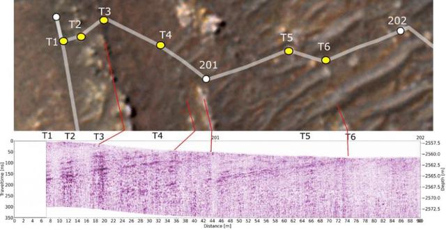
Perseverance's Traverse, Seen From Above and Below
Ücretsiz
Açıklama
This annotated-composite graphic shows the entry of NASA's Perseverance rover into the "South Séítah" geologic unit from both an orbital and subsurface perspective. The annotated view from NASA's Mars Reconnaissance Orbitor (MRO) depicts the route Perseverance took into Séítah. The image was provided by MRO's High Resolution Imaging Experiment (HiRISE). The graphic below the orbital image is the first "radargram" to be released by the Radar Imager for Mars' Subsurface Experiment (RIMFAX) instrument aboard Perseverance. It shows the subsurface as the rover drove across the "Artuby" ridgeline. The red lines link bright subsurface "reflectors" to erosion-resistant layers outcropping at the surf — NASA JPL · 2021. ABD devlet eseri: kamu mali, ticari islerde de serbestce kullanilabilir.
Kaynak ve lisans
Bu eser kamu malı ya da açık lisanslı. Lisans koşulları kaynağın kendi sayfasında yazılı.
Nasıl açılır?
Ürünü indirmek ya da uygulama içinde okumak için Shopy 101 uygulamasını kullan. Kitaplığına eklediğin her şey tüm cihazlarında aynı kalır.